
Pyrenees Atlantiques, Pau, France
Digital Twin Delivers Live Image of Pau, France to Inform Renovation and Ongoing Improvements
Using The iTwin® Platform Saves The City Of Pau Over EUR 200,000 Each Year And Reduces Information Access Costs By 95%
Communaute d’Agglomeration Pau Bearn Pyrenees
An Ambitious Regional Overhaul
The Communauté d’Agglomération de Pau Béarn Pyrénées (CAPBP) coordinates joint policies and actions for regional planning and economic, environmental, cultural, and transportation initiatives for municipalities and cities in the Pau region of France. In 2016, they launched an ambitious renovation plan to improve quality of life and encourage economic development across the region.
CAPBP identified three main challenges that they needed to overcome. First, they needed to promote communication and collaboration between city officials and community members to avoid dissatisfaction with city planning. Second, they wanted to improve the visual appeal of the territory. Third, they wanted to ensure “right first time” construction to prevent unnecessary spending. CABPB needed a solution that could manage the scope of the renovation and enable them to clearly communicate its complexity to stakeholders and community members.
Managing Stakeholders And Increasing Data Access
To improve the quality of their work, CAPBP wanted to create a platform for decision-makers, engineers, and city officials to improve communication, facilitate consultation, and contribute to decision-making by technical and political authorities. They sought a solution that could provide transparency and assist in communication around projects, involving all parties, including city citizens, in decision processes.
However, CAPBP also needed to reduce the costs of asset monitoring and improve efficiency in collecting data. Previously, the city gathered immersive view insights by exporting and producing videos completed by external subcontractors. These videos cost approximately EUR 8,000 per minute and reached over 40 minutes each year. Further, accessing and recording asset information, such as leases and contracts or floor planning, was time- and cost-inefficient. Capturing data from across Pau is no small endeavor. The team had to gather information from 31 municipalities across 370 square kilometers. For CAPBP’s solution to succeed, it needed to collate a vast quantity of data accurately and cost effectively. It should then leverage that data to service their redevelopment initiative, all while ensuring the information was accessible to professionals and the public at large.
Key Takeaways
- CAPBP needed to streamline data and reduce time and costs associated with an ambitious planning initiative.
- The organization wanted all stakeholders to have full access to all data, including the citizens of Pau, to ensure they were satisfied with renovation decisions.
- Using iTwin Capture and OpenCities Planner, they created an urban digital twin to inform data-driven decisions.
- The digital twin reduced the costs of information access by 95%.
- Improving video production reduces costs by over EUR 200,000 each year.
Project Playbook

Going Big With A Digital Twin
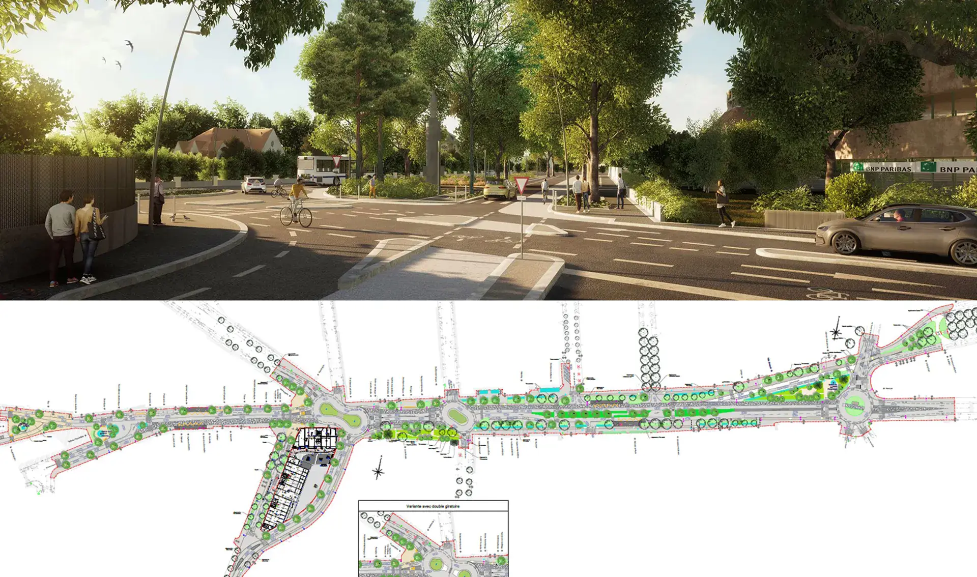
After examining their options, CAPBP determined that they could up-level data acquisition and management by using Bentley applications to create a digital twin of the city. CAPBP began by collecting data at resolutions ranging from five centimeters to 10 centimeters, then wove that data into a multi-scale reality mesh using iTwin Capture. This high-resolution reality mesh serves as the foundational dataset for the digital twin.
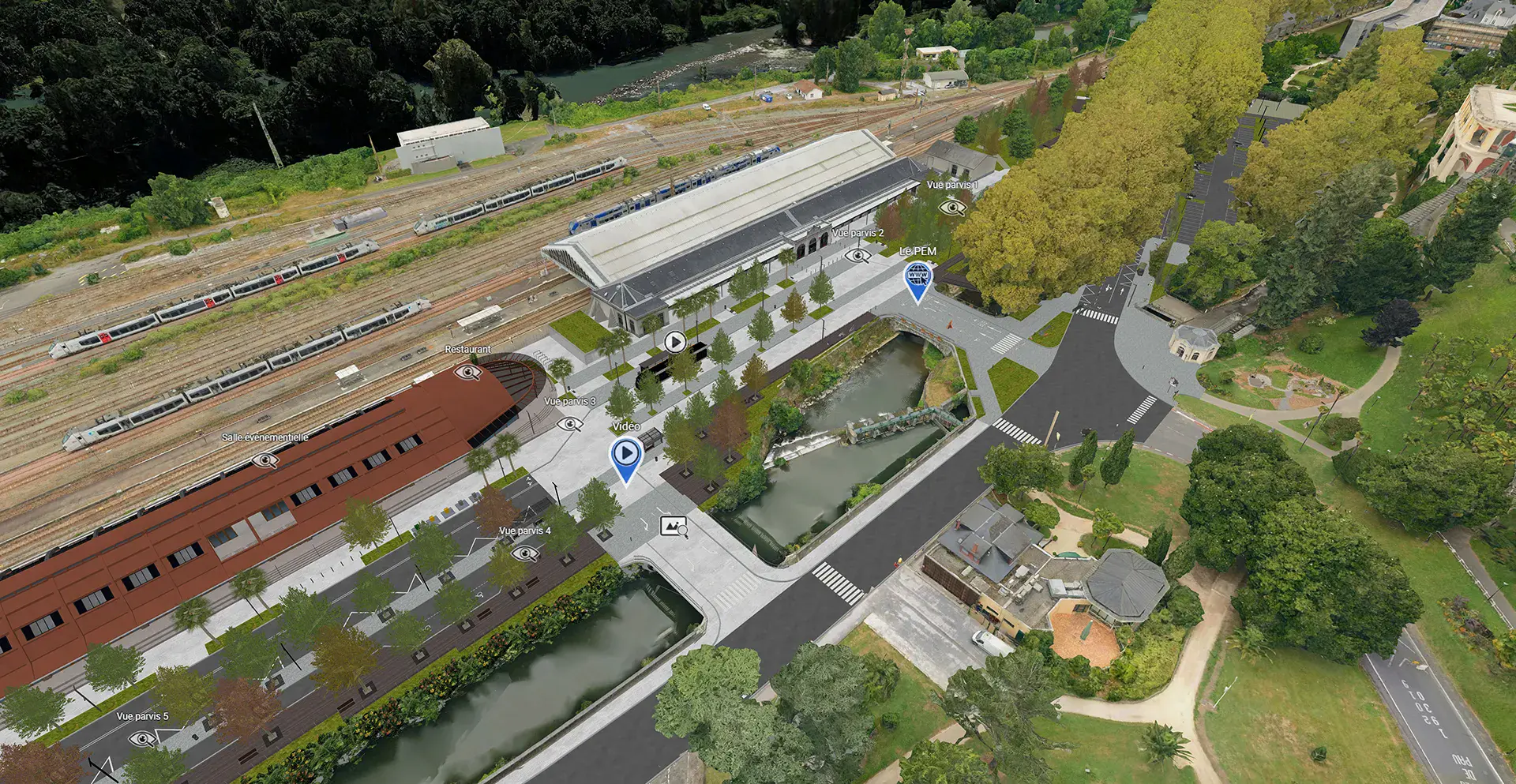
Pau then used the iTwin Platform to build a digital twin that could collate their data into a single connected environment and provide accurate, real-time insights for a variety of stakeholders. With the platform, they processed the varied types of data, including geospatial, engineering, and design, then connected it for multiple use cases, such as utility development, architectural design, and events planning. Because this work was done through a digital twin, technical, political, and civilian stakeholders could have complete access to the same, accurate, up-to-date information.
Clear Communication And Insights Across Departments
Using the digital twin, Pau has improved productivity and reduced costs associated with asset monitoring and management. Now, 60% of Pau’s immersive insight videos can be produced internally, saving almost EUR 200,000 each year. The digital twin also saves time, as accessing asset information—such as lease information and floor planning—takes less than three minutes, resulting in 95% cost savings on information access.
Departments across CAPBP now leverage the digital twin. City planners can simulate traffic scenarios, model architectural projects in real-world context, track progress towards sustainability goals, and view the city’s utility networks from one platform. The organization employs digital twins to monitor stormwater, and plans to soon add capabilities for natural gas, water supply, waste, and electricity. Professionals also use the digital twin for event production, preparing layouts for sporting events and business fairs.
The technology has improved communications, strengthening the relationship between city residents and authorities by engaging the community on decisions about the city’s future. CAPBP can prepare and share information clearly and quickly, building everything from conference presentations to visual museum tours. Citizens can give feedback on urban planning development projects through an interactive 3D model.
Overall, the digital twin’s data transparency and consolidation results in an accurate and detailed representation of the city, making it possible to visualize and plan urban projects with greater precision, reduce the costs associated with last-minute changes, and enable better planning.