Sydney, New South Wales, Australia
Sydney Airport Develops New Gateway for Spatial Data to Improve Operations
Bentley Applications Help Teams Incorporate Reality Models for More Efficient Development and Operations Reviews
Sydney Airport
Reaching The Limits Of Old Spatial Technology
Sydney Airport is one of the oldest airports in the world, as well as Australia’s busiest. Situated on 906 hectares in Botany Bay, it features three runways, three terminals, and 406 buildings. Over the past decade, Sydney Airport has grown to accommodate more than 44 million passengers annually, generating over AUD 42 billion in economic activity during its peak in 2019, before the COVID-19 pandemic. The airport continually initiates development and improvement projects to prepare for an increase in air traffic.
The team at Sydney Airport need keen awareness and access to accurate, detailed, and up-to-date information on the sprawling campus, assets within it, and activities beyond its boundaries, to ensure continued smooth operations. Previously, this information was stored and processed on two sets of specialized software, each requiring VPN access and specialized training. GIS data could only be distributed via static PDFs, and the airport’s aging spatial system could not display laser scans and 3D BIM models, which are quickly becoming standard at airports around the world. Sydney Airport needed to replace their spatial system with advanced technology that would help them improve efficiencies, meet legislative mandates, and satisfy their capacity for growth. “In addition to operational objectives, we have a clear sustainability agenda and strong ambitions for digital transformation,” said Kim Cohen, team leader, GIS, Building Assets and Civil Infrastructure at Sydney Airport.
Seeking A Unified Platform
Ideally, their new spatial system would be a cloud-based, self-service portal providing access to all available spatial and survey information. They wanted users in a variety of disciplines–including aviation and operations, commercial operations, finance and corporate services, and corporate affairs and legal– to gain a comprehensive picture of the airport campus without needing specialized, expensive software installed on every local computer. The platform would need to be accessible and intuitive to all, including those unfamiliar with technical GIS and BIM applications. Sydney Airport wanted the system to federate a mix of complex data, in different formats, from multiple systems, including historical content, digital photography, point clouds, financial systems, and project archives, all in compliance with corporate and legislative requirements.
Yet, Sydney Airport had to do more than just meet current requirements. The new spatial system would also need to provide accurate and easily available data for all future construction projects and planned growth at the airport, which requires scalability and an open environment that could incorporate metadata from a variety of current and future applications. It would also need to unite data previously stored in a variety of legacy systems, which often caused significant bottlenecks and rework. Sydney Airport needed an improved information management system that would display the varying types of data in a meaningful way to all end users, enhancing efficiency and collaboration.
Key Takeaways
- The ability to access all development information within iTwin Experience saves the spatial team roughly 65 resource hours per week.
- Moving from paper-based to digital recordkeeping has reduced the time needed for standard audits from 133 hours to 56 hours.
- The airport team continues to add more data and functionality to the spatial information system and plans to develop it into a true digital twin.
Project Playbook

Enriching Reports With Federated Data
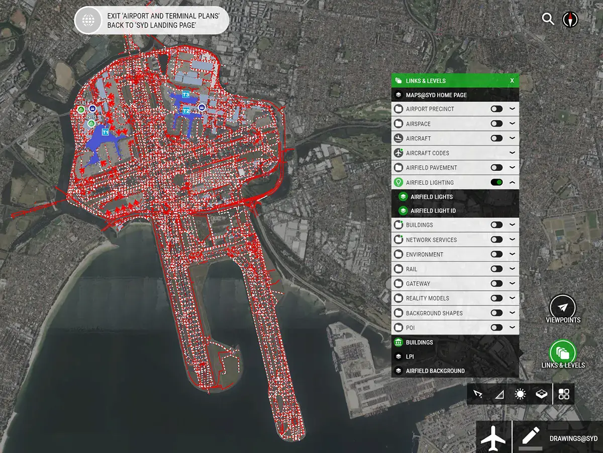
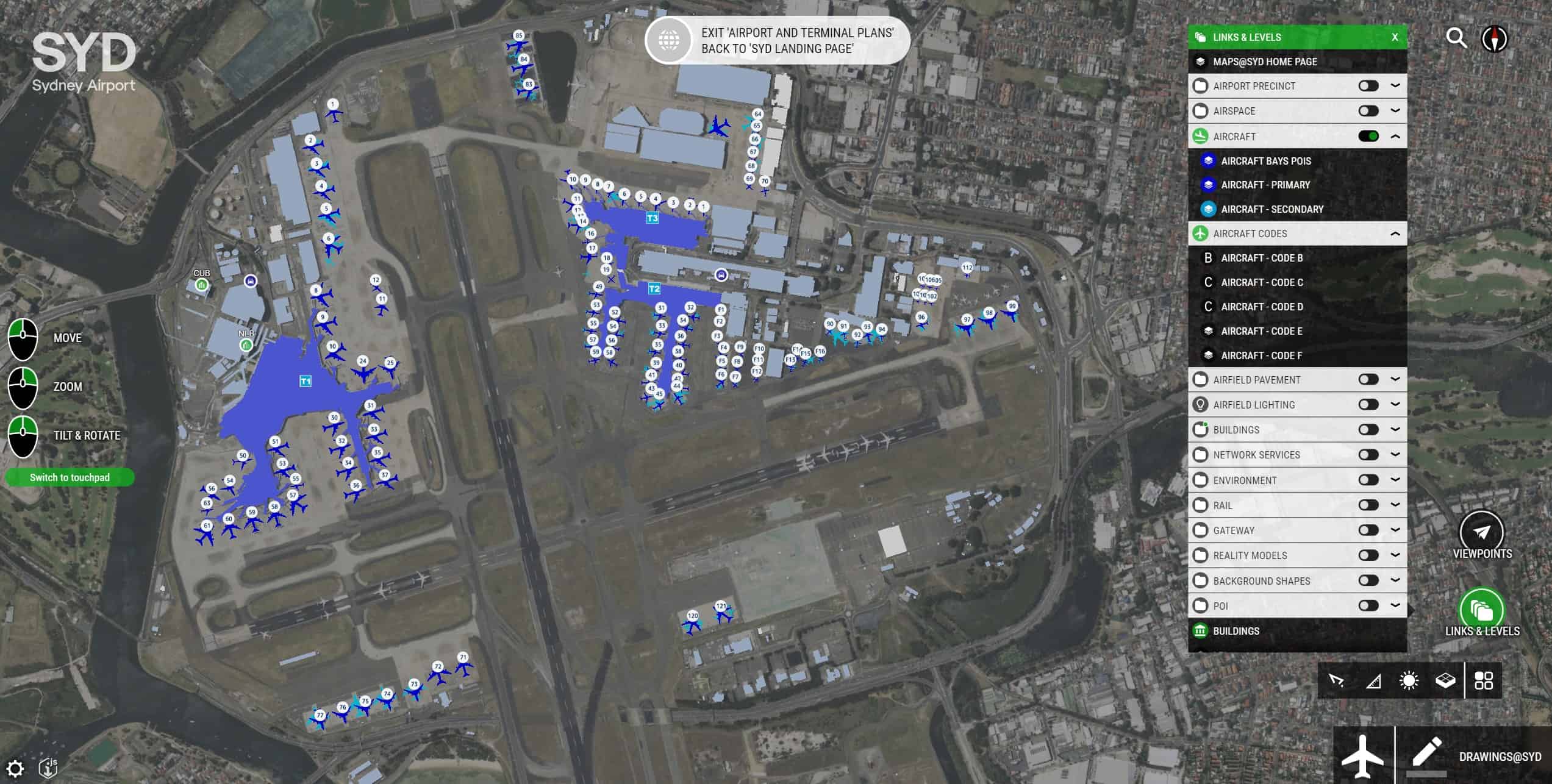
As a longtime user of Bentley Systems applications, Sydney Airport determined that they could use a variety of newer software, including OpenCities Planner, iTwin Capture, and ProjectWise, now combined in Bentley’s iTwin Experience, which forms the basis of their new spatial information system, known as Maps@SYD.
The design team chose Bentley applications because they are based on an open platform and can easily incorporate data in multiple formats, from an array of sources. For example, Maps@SYD can overlay data from financial applications onto GIS data, giving the airport’s commercial leasing team visually intuitive and real-time access to tenant names, lease expiry dates, sales per square meter, and liquor license details, eliminating the need for users to visit the digital print room or request data from the spatial team. Similarly, the spatial team can automatically update and prepare occupancy reports every quarter without needing to consult the leasing team, saving significant time and effort for all involved.
Maps@SYD also helps the team perform regular audits of fire-fighting equipment, video monitoring, flight information display screens, wildlife observations, and confined spaces. Previously, contractors would write information on paper during walkthroughs, before manually uploading data into CAD files, which was error prone and inefficient. Now, having been shown how Maps@SYD operates in a short briefing session, contractors can conduct their audits with tablets and update information directly in the spatial information system. For operations managers going digital, moving away from traditional methods of pen and paper to Maps@SYD, now makes it possible to dynamically analyze the wildlife observation data based on periodic ranges of migration, assisting the decision-making process for strategizing of wildlife management policies.
All users access Maps@SYD via an intuitive web-based portal that divides data into specific sections for different departments and disciplines, such as airport and terminal plans, facilities, development, and safety, sustainability, and environment. Additionally, the system can accommodate reality models created with iTwin Capture, providing detailed information on the existing environment, construction data and progress, plus operational assets. “Maps@SYD is a gateway to historical and real-time data from multiple sources, relating to our physical assets, enabling our people to make informed decisions, facilitate predictive outcomes, improve operational and asset efficiency, mitigate risk, and underpin safety,” said Michael Smith, airport design ofÏcer at Sydney Airport.
Saving Time With Easily Accessible Information
By using Maps@SYD to unify all data within their spatial information system and provide an intuitive portal to airport information, all stakeholders can easily navigate the hundreds of buildings on the campus, enhanced with addresses, floor plans, building services, and photos. Project managers have instant access to all developments, current and planned, with the ability to overlay flood studies, environmentally significant areas, and heritage sites that may impact development. Managers can also overlay operational information, such as aircraft movements, obstructions within and beyond the airfield, plus noise contours, to measure the full impact of development and maintenance activities. Surveyors can input captured images to create reality models of underground services as they are built, providing accurate information without having to revisit the underground site.
The ability to access all information within Maps@SYD saves the spatial team roughly 65 resource hours per week. Tests with users indicated a time savings of over six minutes per search. By the end of 2022, with over 200 users, the team estimates a total time savings of 22 hours per day. Moving from paper-based to digital record-keeping has reduced the time needed for standard audits from 133 hours to 56 hours. While incorporating reality models helps engineers and project managers determine the exact location, depth, and condition of assets, as well as enabling them to check the details of reinstatement works provided by contractors.
With over 150,000 features, hundreds of laser scans, and reality models already in Maps@SYD, the GIS team at Sydney Airport continues to add different data and functionality benefitting the many disciplines involved, and plans to eventually develop it into a true digital twin. “Sydney Airport has commenced its journey towards the development of their digital twin through the implementation of Bentley technology within Maps@SYD, allowing SYD to explore cross-platform data connectivity through their geospatial mapping” said Steve Parker, head of airport design, at Sydney Airport.