- Bentley OpenPaths AGENT
-
Bentley OpenPaths AGENT
Modern Travel Demand Modeling
Bentley OpenPaths AGENT is game-changing travel demand modeling software used to forecast mobility decisions at any level of detail, from zones to individual people. From changing demographics, or residential and work locations, to daily trip patterns including time, location, and mode choice, Bentley OpenPaths AGENT captures realistic representations of mobility to address 21st-century transport planning challenges. And with machine learning built-in, Bentley OpenPaths AGENT takes advantage of new mobility data sources to achieve improved model calibration at reduced time and cost.
Advance Your Travel Demand Model
- Assemble virtually any travel demand model including activity-based (ABM), tour-based, and classic trip-based modeling.
- Upgrade your demand model with improved usability and performance without the high costs of recoding or changing platforms.
- A visual interface, live model validation, and a powerful expression system help you work with travel demand models faster.
- All the capabilities needed for modern travel demand modeling, including population synthesis and comprehensive choice modeling features for both aggregate and disaggregate/microsimulated demand modeing, are at your fingertips.
Leverage All Your Mobility Data
- Machine learning removes the need for tedious and unpredictable trial-and-error model calibration, saving time and costs.
- Automated model calibration procedures simultaneously adjust demand model coefficients against data targets from multiple data sources, allowing better validation.
- Leverage all your mobility data sources to directly improve your travel demand model, incorporating traffic, transit, and origin-destination counts as well as big data in addition to or instead of household travel survey (HHTS) data.
Bentley OpenPaths AGENT is only available in the Bentley OpenPaths Ultimate edition.
- Bentley OpenPaths EMME
-
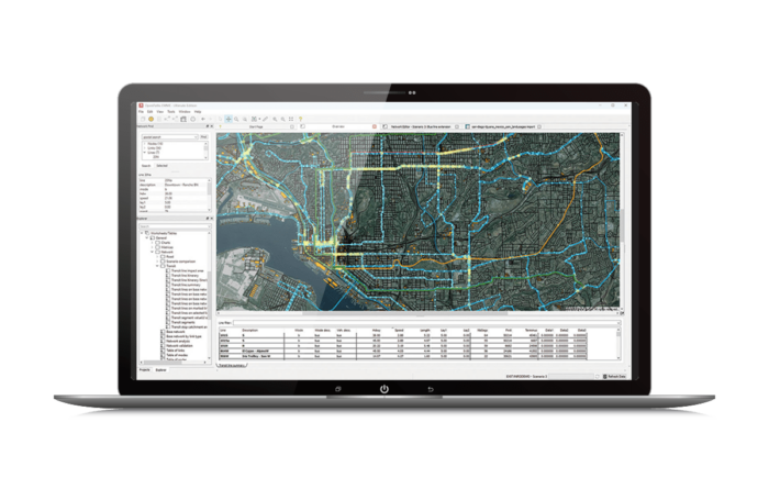 Bentley OpenPaths EMME
Multimodal Transportation Planning
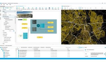
Bentley OpenPaths EMME is a complete transportation forecasting application for planning the urban, regional, and national movement of people. Bentley OpenPaths EMME is used to create digital transport models for travel demand forecasting, traffic planning, transit service planning, and related needs to provide an evidence base for transport strategy and policy decision-making. By modeling the people, places, processes, and options involved in travel, transport planners can evaluate transport system performance on any number of virtual scenarios prior to implementation.
Leading Transport Modeling
- Traffic, public transit, and multimodal network and demand modeling procedures trusted by leading transport agencies.
- Uniquely flexible models may be tailored to support local applications or new model procedures.
- Work efficiently with out-of-the-box support for crowded transit, fare integration, tolling, junction delay, active transport, and service planning applications.
- Integrates natively with Bentley OpenPaths AGENT for advanced demand modeling. (Bentley OpenPaths AGENT is only available in the Bentley OpenPaths Ultimate edition)
Accelerate Productivity
- Extensive maps, charts, reports, and scenario comparisons provide data transparency and help turn results into insights.
- Code-free and code-friendly. Easily configure model procedures with a visual control flow system that anyone on the team can use, or customize procedures and manage model-as-code with comprehensive Python APIs for developers.
- Manage all your mobility data, including multimodal networks, travel demand, surveys, demographics, and travel results, including households, persons, trips, and tours.
- Create 3D animations across time or between planning scenarios to understand regional mobility patterns at scale.
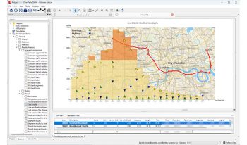
- Bentley OpenPaths CUBE
-
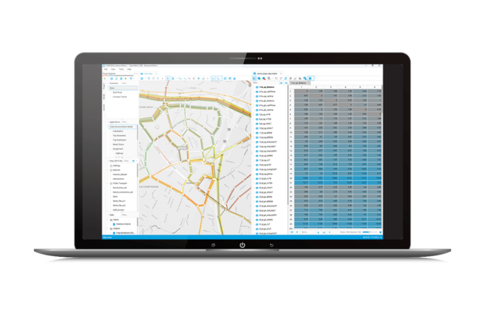 Bentley OpenPaths CUBE
Multimodal Transportation Planning
Bentley OpenPaths CUBE Is multimodal transport planning software that is used to develop and apply predictive multimodal transportation models to simulate how changes in infrastructure, operations, technology, and demographics will impact movement and accessibility of a given area. Bentley OpenPaths CUBE lets you analyze the effects of new projects and policies on a city’s transportation network and its population. Bentley OpenPaths CUBE provides a desktop interface to link a model, data, and geographic information system (GIS), easing the development and application of your models.
Make Informed Decisions
- Visualize, test, and compare multiple scenarios with a complete library of multimodal transport modeling procedures.
- Integrates natively with Bentley OpenPaths AGENT for advanced demand modeling. (Bentley OpenPaths AGENT is only available in the Bentley OpenPaths Ultimate edition)
- Easily manage changes in input data with comprehensive scenario management features.
- Advise on the suitability of planning and design decisions to support business cases.
Accelerate Project Delivery
- Access libraries of transport modeling functions to save time when developing models.
- Use an intuitive flow-charting interface to organize model processes and quickly complete modeling tasks.
- Benefit from Python APIs and flexible integration with third-party applications.
- Reduce rework and errors, and streamline processes with powerful spatial technology.
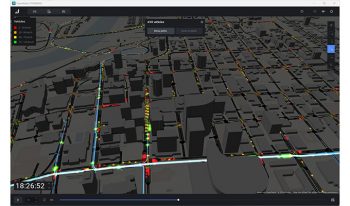
- Bentley OpenPaths DYNAMEQ
-
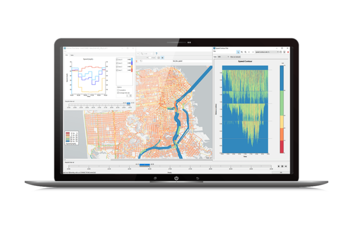
Bentley OpenPaths DYNAMEQ
Traffic Simulation and Dynamic Traffic Assignment (DTA)
Bentley OpenPaths DYNAMEQ is a traffic simulation and dynamic traffic assignment (DTA) software for transport planning and traffic management studies of virtually any size. Whether you are implementing freeway or urban congestion pricing, planning major infrastructure rehabilitation, or undertaking road improvements, transit planning or neighborhood redevelopments, Bentley OpenPaths DYNAMEQ allows you to accurately assess the related traffic and mobility impacts.
Traffic simulation that lets you see the whole picture
- Simulates vehicles with car-following, lane changing, and gap acceptance models to produce realistic traffic behavior.
- High-performance animations provide a 3D, 360° visualization and analysis environment.
- Production-quality video allows you to storyboard and share intuitive animations.
Rapidly develop models of any size
- Get started quickly with importers for a range of popular transportation software and data formats.
- Streamline model development with comprehensive network data validation and cleaning capabilities that make it easy to identify and resolve issues.
- Develop future scenarios by synthesizing traffic signals and turning movement parameters that are adapted to future travel demand.
Calibrate your models with confidence
- Spend less time calibrating and more time testing scenarios with fast run times and fewer calibration parameters.
- Achieve higher calibration metrics than ever before with a proven simulation-based demand adjustment capability.
- Generate reliable and reproducible results even for high-demand future-year scenarios.
Bentley OpenPaths DYNAMEQ is only available in the Bentley OpenPaths Ultimate edition.
- Bentley OpenPaths CityPhi
-
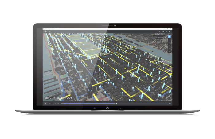
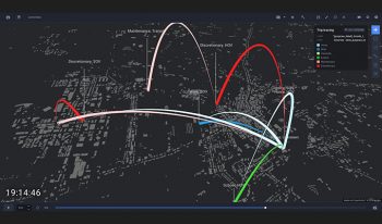
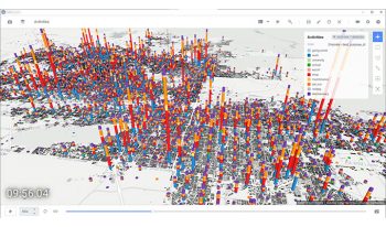
Bentley OpenPaths CityPhi
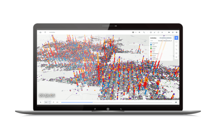
Mobility Animation Studio
Bentley OpenPaths CityPhi provides an API to produce captivating data visualizations, interactive animations, and insightful analytics about mobility and location by turning data about the movement of people and things, their location, and their changing social, economic, and physical characteristics into dynamic scenes. With Bentley OpenPaths CityPhi you can create applications that let users explore time, space, and motion with interactive animations that stay responsive at scale.
A Digital Lens on Mobility
- Create compelling visual representations of mobility data, including trajectories, paths, points, or any kind of time-based location or movement data.
- Animate, explore, color, filter, label, and query mobility data to uncover relationships and develop a clearer understanding.
- Import and work with mobility data including General Transit Feed Specification (GTFS), fare card data, GPS and cell phone records, social media activity, travel surveys, land use models, and agent-based simulation results.
- Save production-quality videos with scripted camera keyframe animations.
Mobility Development Kit
- Develop analytics and visual treatments, and load your own data with native Bentley OpenPaths CityPhi Python libraries.
- Create the right scene with fifteen visual layers and dozens of parameters to configure and play back through time.
- Incorporate Bentley OpenPaths CityPhi into modern Python data science workflows using Jupyter Notebook with a reactive UI.
Bentley OpenPaths AGENT
Modern Travel Demand Modeling
Bentley OpenPaths AGENT is game-changing travel demand modeling software used to forecast mobility decisions at any level of detail, from zones to individual people. From changing demographics, or residential and work locations, to daily trip patterns including time, location, and mode choice, Bentley OpenPaths AGENT captures realistic representations of mobility to address 21st-century transport planning challenges. And with machine learning built-in, Bentley OpenPaths AGENT takes advantage of new mobility data sources to achieve improved model calibration at reduced time and cost.
Advance Your Travel Demand Model
- Assemble virtually any travel demand model including activity-based (ABM), tour-based, and classic trip-based modeling.
- Upgrade your demand model with improved usability and performance without the high costs of recoding or changing platforms.
- A visual interface, live model validation, and a powerful expression system help you work with travel demand models faster.
- All the capabilities needed for modern travel demand modeling, including population synthesis and comprehensive choice modeling features for both aggregate and disaggregate/microsimulated demand modeing, are at your fingertips.
Leverage All Your Mobility Data
- Machine learning removes the need for tedious and unpredictable trial-and-error model calibration, saving time and costs.
- Automated model calibration procedures simultaneously adjust demand model coefficients against data targets from multiple data sources, allowing better validation.
- Leverage all your mobility data sources to directly improve your travel demand model, incorporating traffic, transit, and origin-destination counts as well as big data in addition to or instead of household travel survey (HHTS) data.
Bentley OpenPaths AGENT is only available in the Bentley OpenPaths Ultimate edition.
Bentley OpenPaths EMME
Multimodal Transportation Planning
Bentley OpenPaths EMME is a complete transportation forecasting application for planning the urban, regional, and national movement of people. Bentley OpenPaths EMME is used to create digital transport models for travel demand forecasting, traffic planning, transit service planning, and related needs to provide an evidence base for transport strategy and policy decision-making. By modeling the people, places, processes, and options involved in travel, transport planners can evaluate transport system performance on any number of virtual scenarios prior to implementation.
Leading Transport Modeling
- Traffic, public transit, and multimodal network and demand modeling procedures trusted by leading transport agencies.
- Uniquely flexible models may be tailored to support local applications or new model procedures.
- Work efficiently with out-of-the-box support for crowded transit, fare integration, tolling, junction delay, active transport, and service planning applications.
- Integrates natively with Bentley OpenPaths AGENT for advanced demand modeling. (Bentley OpenPaths AGENT is only available in the Bentley OpenPaths Ultimate edition)
Accelerate Productivity
- Extensive maps, charts, reports, and scenario comparisons provide data transparency and help turn results into insights.
- Code-free and code-friendly. Easily configure model procedures with a visual control flow system that anyone on the team can use, or customize procedures and manage model-as-code with comprehensive Python APIs for developers.
- Manage all your mobility data, including multimodal networks, travel demand, surveys, demographics, and travel results, including households, persons, trips, and tours.
- Create 3D animations across time or between planning scenarios to understand regional mobility patterns at scale.
Bentley OpenPaths CUBE
Multimodal Transportation Planning
Bentley OpenPaths CUBE Is multimodal transport planning software that is used to develop and apply predictive multimodal transportation models to simulate how changes in infrastructure, operations, technology, and demographics will impact movement and accessibility of a given area. Bentley OpenPaths CUBE lets you analyze the effects of new projects and policies on a city’s transportation network and its population. Bentley OpenPaths CUBE provides a desktop interface to link a model, data, and geographic information system (GIS), easing the development and application of your models.
Make Informed Decisions
- Visualize, test, and compare multiple scenarios with a complete library of multimodal transport modeling procedures.
- Integrates natively with Bentley OpenPaths AGENT for advanced demand modeling. (Bentley OpenPaths AGENT is only available in the Bentley OpenPaths Ultimate edition)
- Easily manage changes in input data with comprehensive scenario management features.
- Advise on the suitability of planning and design decisions to support business cases.
Accelerate Project Delivery
- Access libraries of transport modeling functions to save time when developing models.
- Use an intuitive flow-charting interface to organize model processes and quickly complete modeling tasks.
- Benefit from Python APIs and flexible integration with third-party applications.
- Reduce rework and errors, and streamline processes with powerful spatial technology.
Bentley OpenPaths DYNAMEQ
Traffic Simulation and Dynamic Traffic Assignment (DTA)
Bentley OpenPaths DYNAMEQ is a traffic simulation and dynamic traffic assignment (DTA) software for transport planning and traffic management studies of virtually any size. Whether you are implementing freeway or urban congestion pricing, planning major infrastructure rehabilitation, or undertaking road improvements, transit planning or neighborhood redevelopments, Bentley OpenPaths DYNAMEQ allows you to accurately assess the related traffic and mobility impacts.
Traffic simulation that lets you see the whole picture
- Simulates vehicles with car-following, lane changing, and gap acceptance models to produce realistic traffic behavior.
- High-performance animations provide a 3D, 360° visualization and analysis environment.
- Production-quality video allows you to storyboard and share intuitive animations.
Rapidly develop models of any size
- Get started quickly with importers for a range of popular transportation software and data formats.
- Streamline model development with comprehensive network data validation and cleaning capabilities that make it easy to identify and resolve issues.
- Develop future scenarios by synthesizing traffic signals and turning movement parameters that are adapted to future travel demand.
Calibrate your models with confidence
- Spend less time calibrating and more time testing scenarios with fast run times and fewer calibration parameters.
- Achieve higher calibration metrics than ever before with a proven simulation-based demand adjustment capability.
- Generate reliable and reproducible results even for high-demand future-year scenarios.
Bentley OpenPaths DYNAMEQ is only available in the Bentley OpenPaths Ultimate edition.
Bentley OpenPaths CityPhi
Mobility Animation Studio
Bentley OpenPaths CityPhi provides an API to produce captivating data visualizations, interactive animations, and insightful analytics about mobility and location by turning data about the movement of people and things, their location, and their changing social, economic, and physical characteristics into dynamic scenes. With Bentley OpenPaths CityPhi you can create applications that let users explore time, space, and motion with interactive animations that stay responsive at scale.
A Digital Lens on Mobility
- Create compelling visual representations of mobility data, including trajectories, paths, points, or any kind of time-based location or movement data.
- Animate, explore, color, filter, label, and query mobility data to uncover relationships and develop a clearer understanding.
- Import and work with mobility data including General Transit Feed Specification (GTFS), fare card data, GPS and cell phone records, social media activity, travel surveys, land use models, and agent-based simulation results.
- Save production-quality videos with scripted camera keyframe animations.
Mobility Development Kit
- Develop analytics and visual treatments, and load your own data with native Bentley OpenPaths CityPhi Python libraries.
- Create the right scene with fifteen visual layers and dozens of parameters to configure and play back through time.
- Incorporate Bentley OpenPaths CityPhi into modern Python data science workflows using Jupyter Notebook with a reactive UI.