Substation Flood Risks Assessment, Monitoring and Early Warning System
SUSTAINABILITY CHALLENGE
One of the 4 Key Sustainability Challenges
Story Highlights
UTILIZED SOFTWARE
Bentley Software
LOCATION
ORGANIZATION/COMPANY
PROJECT SUMMARY
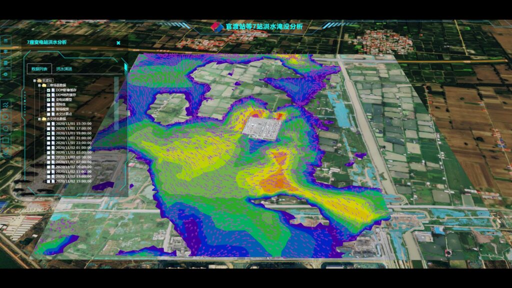
PowerChina Henan Electric Power Survey & Design Institute Co., Ltd. developed a Substation Flood Risks Assessment, Monitoring, and Early Warning System to protect critical 500kV substations in Zhengzhou, China, against extreme rainfall like the ‘21.7’ event. This RMB 2 Million project achieved 40% time savings and improved quality/efficiency by over 60% through a digital twin approach. The system uses 3D laser scanning and AI (PointNet++, RandLA-Net) for automated point cloud noise removal and semantic segmentation, enabling the precise 3D modeling of substation equipment. OpenFlows Sewer establishes 2D surface water models to predict flood water level and flow under different rainstorm conditions. The solution unifies multi-source data (aerial, terrain, BIM, sensor) via Bentley Cesium and WebGL for a realistic 3D flood deduction and early warning platform. This innovative system forms a complete disaster perception and simulation framework, reducing the grid’s vulnerability to extreme weather and achieving an international leading level in technology.
Relevant UN Sustainable Development Goals (SDGs)
SDG Goal 1
No Poverty
End poverty in all its forms everywhere.
SDG Goal 2
Zero Hunger
End hunger, achieve food security and improved nutrition and promote sustainable agriculture.
SDG Goal 3
Good Health and Well-Being
Ensure healthy lives and promote well-being for all at all ages.
SDG Goal 4
Quality Education
Ensure inclusive and equitable quality education and promote lifelong learning opportunities for all.
SDG Goal 5
Gender Equality
Achieve gender equality and empower all women and girls.
SDG Goal 6
Clean Water and Sanitation
Ensure availability and sustainable management of water and sanitation for all.
SDG Goal 7
Affordable and Clean Energy
Ensure access to affordable, reliable, sustainable and modern energy for all.
SDG Goal 8
Decent Work and Economic Growth
Promote inclusive and sustainable economic growth, full employment, & decent work for all.
SDG Goal 9
Industry, Innovation and Infrastructure
Build resilient infrastructure, promote inclusive and sustainable industrialization & foster innovation.
SDG Goal 10
Reduced Inequalities
Reduce inequality within and among countries.
SDG Goal 11
Sustainable Cities and Communities
Make cities and human settlements inclusive, safe, resilient and sustainable.
SDG Goal 12
Responsible Consumption and Production
Ensure sustainable consumption and production patterns.
SDG Goal 13
Climate Action
Take urgent action to combat climate change and its impacts.
SDG Goal 14
Life Below Water
Conserve and sustainably use the oceans, seas and marine resources for sustainable development.
SDG Goal 15
Life on Land
Sustainably manage ecosystems, combat desertification, reverse land degradation, & halt biodiversity loss.
SDG Goal 16
Peace, Justice and Strong Institutions
Foster peaceful & inclusive societies, ensure justice access, & build effective, accountable institutions at all levels.
SDG Goal 17
Partnerships for the Goals
Strengthen the means of implementation & revitalize the Global Partnership for Sustainable Development.
