OCT 06, 2026
With A 3D Model of Its Underground, Vienna Digs Into its Future
As its population, tourism, and reputation keep climbing, Vienna is boring a new metro line through some of the trickiest, most varied ground in Europe — guided by a 3D model of the city's subsurface that started, fittingly, on a rooftop.
By Jay Moye
Key takeaways:
- A 3D model built from 70,000 boreholes, some logged 200 years ago, now covers half of Vienna's subsurface.
- Mapping where gravel meets clay prevents costly tunneling surprises for crews building the city’s new metro.
- Record tourism and 2 million residents strain Vienna's transit.
Brilliant ideas came out of the conversations among painters, composers, and engineers in Vienna's famous cafés in the 1920s. Among those ideas, though perhaps lesser known, was soil mechanics, founded by the Austrian engineer and geologist Karl Terzaghi. He applied the laws of mechanics and hydraulics to soil, a domain where engineers had previously relied almost exclusively on experience and guesswork—and his work changed how we build things. Today, engineers in the city where he worked and taught are applying Terzaghi's equations beneath its streets, boring one of Europe’s newest metros through some of the continent's trickiest ground.
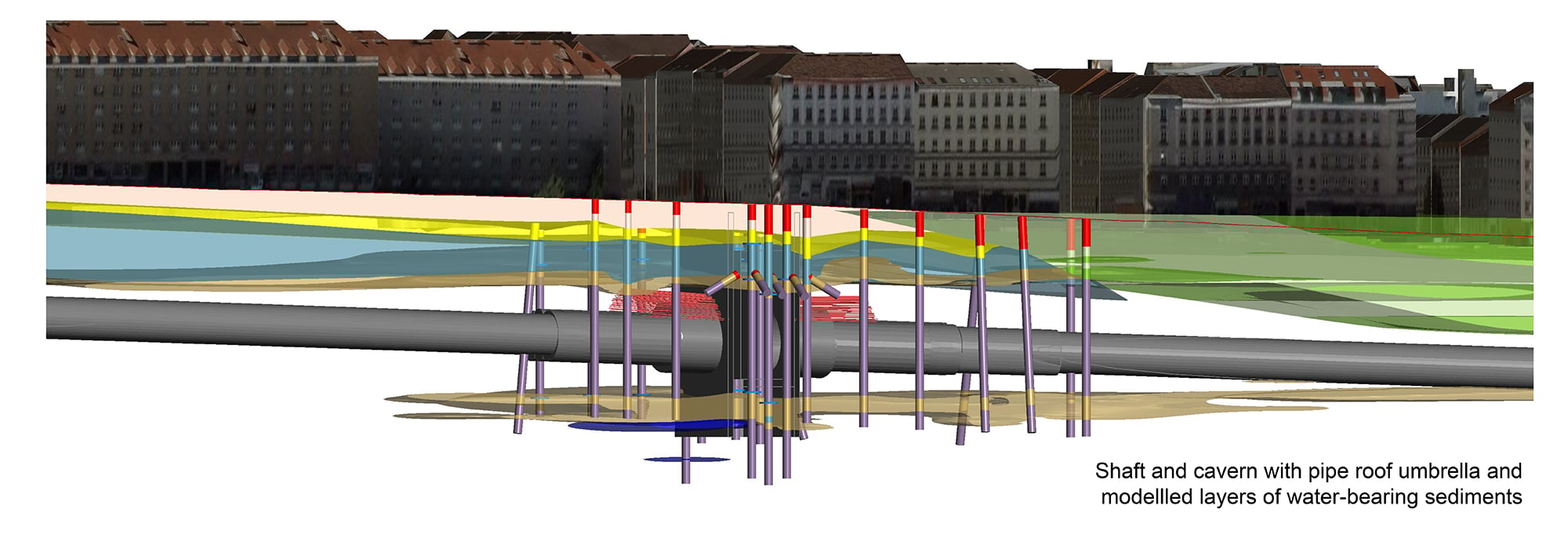
The Austrian capital sits low in a river landscape that the mighty Danube spent the last several hundred thousand years building. As the river shifted course again and again, through the Pleistocene and into the present, it left behind a staircase of gravel terraces stepping down toward its current channel. The result is six distinct levels that underlie roughly 60% of the city, according to geological surveys of the area, each one a slab of sand and gravel deposited by an older version of the river. Individually, they're not thick: typically somewhere in the range of 4 to 16 meters, depending on which terrace and where. But the lowest of them hold a lot of water and serve as important aquifers. They also sit close enough to the surface to affect almost anything built below street level.
Under the Blue Danube
Underneath that gravel is where the ground actually gets old. The Vienna Basin itself was a marine and lake basin for millions of years, and the fine-grained sediment that settled into it over that time—silty, stiff, often clay-rich—runs kilometers deep in places.
Threading a subway tunnel through them is the job of Jonas Weil, a geologist with iC Group who has spent the past decade building the 3D model for the city's new extension of the U2 metro line.
And it’s the contact between the geologically young, loose, water-bearing gravel above the much older, stiffer material below that Weil keeps coming back to.
“There's always one important contact,” he said. “There's no bedrock contact, but there's a contact between gravel and more stiff soils, which is usually very important for foundations and groundwater.” Get that boundary wrong—build a foundation assuming stiff ground that turns out to be loose, water-bearing gravel, for example, or plan dewatering for a tunnel that's below an aquifer—and the consequences show up as cost, delay, or worse. Get it right, and it barely makes news. Or as Weil puts it: less drama, more schedule.
How Vienna's 3D geological model works
The model draws on a municipal database of roughly 70,000 boreholes, some barely a year old and others transcribed from 200-year-old hand-drawn geological logs that Terzahgi and his predecessors collected. Weil's team has integrated somewhere between 10,000 and 15,000 of those logs into the model. It started at just one station and included only one layer. But the model became so helpful that it now covers nearly half of the city, including 7 kilometers of the new metro line.
“We cover the easy part of the city, the simple geology,” Weil admits. But he’s ready to take on the next challenge. “When you come more to the west, you come into the hills, and there's more bedrock and tectonics, and it's going to be much more complicated to model.”
Why Vienna needs the U2 and U5
Prized for its culture, healthcare, and infrastructure, Vienna has repeatedly ranked near or at the top of the Economist Intelligence Unit's Global Liveability Index, an annual ranking of major cities worldwide based on their quality of life and urban living conditions. Naturally, as its reputation shines ever more brightly, the city is attracting more people: Greater Vienna is now home to more than 2 million people, and 2025 marked the city's biggest tourism year on record, with more than 20 million overnight stays.
In other words, Vienna very much needs the U2 metro extension in addition to another new metro line, the U5.
Ulli Sima, executive city councilor for innovation, urban planning, and mobility, said in July that the projects will “relieve existing lines and create additional capacity for up to 300 million passengers annually."
Seeing the big picture
Vienna's answer to moving more people lies underground, but the conversation that introduced a key element to the process took place on a rooftop.
In 2017, geologist Pat McLarin, who serves as segment director for civil engineering at Seequent, the Bentley Systems sub-surface company, climbed onto the rooftop terrace of iC Group's office in Vienna. Joined by Weil, they chatted while taking in views of the bustling city. Then McLarin gave Weil a present: a new piece of 3D modeling software called Leapfrog Works. Seequent originally created it for mapping ore deposits in mines, but Weil could use it to model Vienna’s tricky underground.
“The Leapfrog Works story starts in Vienna,” said McLarin, who lives in New Zealand. “He was the first user of the software, formally released.” What the two of them settled on that day was less a piece of software than a habit: Instead of drilling and interpreting boreholes fresh for every station, every line, or every extension, teams could build one model and keep adding to it.
That habit is what turned Vienna's stubborn geology into something almost routine. Anywhere inside the modeled zone, Weil's team—or increasingly, the municipality itself—can check exactly where that critical gravel contact sits without turning a single new drill bit.
In July, Weil attended an event celebrating a project milestone: The boring machine cutting the U2 metro extension broke through its final meters of ground — the same ground his model had spent a decade describing.
Days later, McLarin walked a section of the finished tunnel himself. He remembers the crew half-joking about how routine the job had become. “It was nice and cool down in the tunnels, while the heat wave was hitting above,” he said.
Above ground, Vienna keeps composing, debating, and filling its coffeehouses. Below it, for the first time, the city finally knows exactly what it's standing on.