PLAXIS Designer
3D Geotechnical conceptual Model Software
Reduce design and analysis time
Trim design and analysis time by using the right software for the project.
Use engineered earth structures, construction, topology, borehole, and water data.
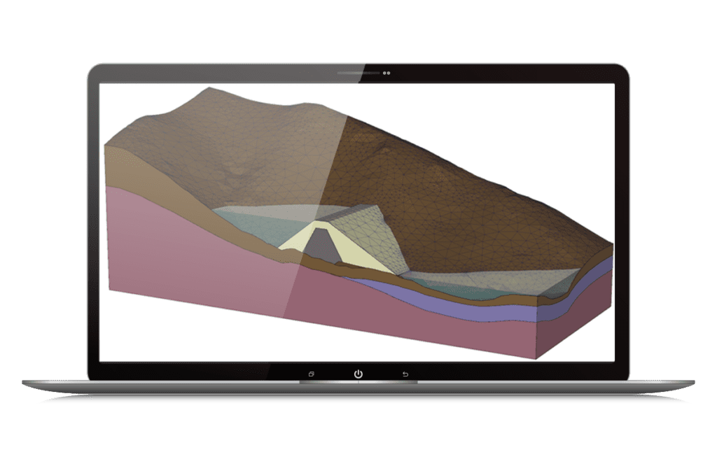
What is PLAXIS Designer?
PLAXIS Designer is an easy-to-use application for creating 3D conceptual models with stunning visuals. It eliminates the pain of merging and analyzing data. With Bentley’s open modeling environment, PLAXIS Designer helps you visualize and adjust geotechnical site data including topology, boreholes, piezometers, and field instrumentation data, as well as engineering staged construction and design.
Design to Analysis
Conceptual models can be exported to PLAXIS 3D LE, PLAXIS 2D LE, and PLAXIS 2D, for slope stability, stress, deformation, consolidation, and groundwater analysis. You can also import boreholes from a gINT database or create them manually.
Construction Sequences and Volume Calculations
Generate construction sequences by building layers of material to create roads, embankments, earth dams, or user-defined shapes. Calculate volumes of material to aid in planning.
Integrate field data
Integrated field data, such as piezometer data, can be pulled from various cloud platforms to display piezometer locations and water levels as a function of time.
PLAXIS Designer
- Save modeling time
- Create construction sequences
- Produce visuals for clients
- Perform material volume calculations
- Represent complex 3D surfaces
*Prices vary per region. For more options, see licensing and subscriptions section.
User QuoteS
"PLAXIS Designer has some fantastic features for rapidly and easily building and editing 3D open pit models that have complex geology. Not only that, but these 3D models can be used to automatically generate and solve any number of 2D limit equilibrium models, which is an industry game changer!"
— Ken Mercer, PH.D., Mining Engineer, 3rd Rock Consulting
“We were able to quickly develop the conceptual 3D model using topographic data, borehole logs, and 2D geologic cross-sections. Once the conceptual model was built, we were able to analyze potential failure locations in excellent time. We highly recommend this software for analyzing similar projects.”
— Scott T. Anderson, Sr. Geotechnical Engineer, HDR Engineering
FEATURED USER STORIES

Golder Associates
Strengthens One of the World’s Largest Subsea TBM Tunnels
Modeling with Bentley’s geotechnical applications ensured quality, safety, and a service life of 120 years.
SAIDEL Engineering
Residential Building above Subway Tunnels
PLAXIS provided the industry model, promoting future development over West Bucharest’s tunnels.

Arup Singapore
3D Soil Simulations to Design Tower Foundation
The project team saved resource hours and avoided having to use multiple software platforms.
PLAXIS Software Resources
Frequently Asked Questions
PLAXIS Designer is an easy-to-use application for building 3D conceptual models that can help you overcome the challenges of merging and analyzing data. With Bentley’s open modeling environment, PLAXIS Designer enables you to visualize and manipulate geotechnical site data such as topology, boreholes, piezometers, and other field instrumentation data, as well as engineering staged construction and design. Important changes to PLAXIS LE and PLAXIS Designer Support. Learn more about alternative and migration options.
PLAXIS Designer tutorials can be found on Bentley Communities. Additionally, here are some FREE PLAXIS learning resources available at on our eStore.
If you want to receive tailored training or attend PLAXIS Designer course, Bentley offers extra training and mentoring services. You can choose from tailor-made training, on-demand learning, consulting services, mentoring and more. Learn more about Expert Services here.
The cost of PLAXIS Designer varies per region. While there are various types of licensing available, a common choice is the 12-month practitioner license offered through Bentley’s eStore. When you purchase through the eStore, you get a Virtuoso Subscription which means you get both the software AND the training, expert services, and custom mentoring you need to get started quickly.
Seequent, The Bentley Subsurface Company | Seequent is the subsurface software company within Bentley Systems. Together, we’re helping build a more resilient future by connecting the built world above ground with the hidden world below it. It’s easy to purchase a Virtuoso Subscription, through Virtuosity, Bentley’s eStore, and still get the expert technical support from Seequent’s subsurface experts.
Operating System
Windows 10, Windows 11
Processor
Intel Pentium-based or AMD Athlon-based PC or workstation
Memory
4 GB minimum, 8 GB recommended, (more memory typically results in better performance)
Display Resolution
1024 px by 768 px or better
Hard Disk
2 GB free disk space
Video
256 MB VRAM minimum, with full support for OpenGL 3.3
For the most up-to-date system requirements, visit Bentley Communities.
Licensing and Subscription options
Choose What is Right for You
One-year license with training
Virtuoso Subscription – A popular choice for small and medium-sized businesses
Get access to software that comes with training – fast! Bentley’s eStore, Virtuosity, offers a convenient way to lease a 12-month license of Bentley software for a low, upfront cost. Every online purchase through Virtuosity comes as a Virtuoso Subscription that includes training and auto-renewals.
With no contract required, it’s easy to get started quickly.
One-time purchase with support
Perpetual License with SELECT
A perpetual license of Bentley software is a one-time purchase, with a yearly maintenance subscription, called SELECT. This includes 24/7/365 technical support, learning resources, and the ability to exchange licenses for other software once a year. With SELECT, you will benefit from:
- License pooling, so you can access your software from multiple computers.
- Access additional Bentley software with Term Licenses, which allow you to pay for what you use without the upfront cost of purchasing a perpetual license.
Annual renewal quotes are delivered directly to your inbox, and our experienced Renewal Representatives are available to answer your questions and guide you through any changes you’d like to make.
Enterprise Organizations
We’ve got your back
For larger organizations with in-depth requirements, we offer plans to provide global pricing and access to our comprehensive portfolio of solutions and success plan services. Contact us about how to get access to software, global best practices, implementation services, training, and technical support to help your organization realize its full potential while addressing your unique needs.
